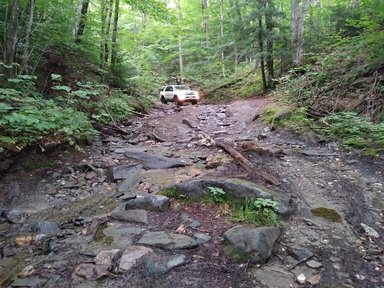
 Photo Credit: Josh Loveland https://www.appalachianbyway.com/ab-maps/vermont-and-new-hampshire Photo Credit: Josh Loveland https://www.appalachianbyway.com/ab-maps/vermont-and-new-hampshire In April 2018, I received an email from Josh Loveland asking a few questions about the Georgia Overland website and my experience mapping and publishing The Georgia Traverse. The message went on to say that Josh had spent the last year developing an incredible, 2,400 mile East Coast overland route that connected to The Georgia Traverse in Dillard, Georgia. Knowing the amount of effort it takes to carefully map a local route, I was intrigued to hear more about his unbelievable, multi-state 2,400 mile route. We exchanged emails and phone calls over the months that followed as he finalized the route and built his Appalachian Byway website.
The Appalachian Byway is a monumental effort. The route Josh developed includes "...over 2,400 miles of back roads, dirt roads, and scenic mountain passes. It follows the Appalachian trail all the way from the southern terminus in Georgia to the northern terminus in Maine." Josh offers seven .gpx files including Maine, Vermont/New Hampshire, New York/Connecticut/Massachusetts, Pennsylvania/New Jersey, Northern Virginia, Southern Virginia, North Carolina/Tennessee. Together, the seven .gpx files cover the entire 2,400 miles of the Appalachian Byway route. If you enjoy long distance, scenic or overland travel you really need to visit The Appalachian Byway. Also, be sure check out his Build Your Own Adventure page that provides additional information and mapping resources for overland travel along the East Coast. One last thing: Josh is a member of HMB Overland, which has the really cool and notable distinction of being one of ten Tepui 'Endless Adventure' teams. Read more about their trip here. Safe travels, David |
Archives
February 2020
|
 RSS Feed
DISCLAIMER | ABOUT | THE ADVENTURE TRAVEL LIBRARY
Copyright © 2010-2023 All Rights Reserved David Giguere | Georgia Overland | Georgia Traverse™
All materials on this site are protected by copyright and intellectual property laws and are the property of David Giguere.
Unless stated otherwise, you may access and download the materials located on www.georgiaoverland.com only for personal, non-commercial use.
You may not reproduce this material on your personal website, blog, social network, or any other online, offline, digital or print resource without permission granted by David Giguere.